The announcement was made at a reception hosted by CDU
ER Mapper has announced it will provide low-cost licences of its flagship image processing software to key land and natural resource management agencies in eastern Indonesia and possibly East Timor, through CDU project activities in the region.
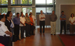
The generous discount was announced at a reception hosted by Charles Darwin University (CDU) early last week. The reception took place at the Mal Nairn Foyer and was arranged to welcome a study tour.
CDU has a long association with eastern Indonesia, particularly through collaborative research and training in the area of natural resource mapping and management for improved rural livelihoods.
CDU recently completed a three year project funded by the Australian Centre for International Agricultural Research (ACIAR) that focused on fire management in eastern Indonesia. ER Mapper was used extensively in this project to process remotely sensed data for the purposes of fire and land cover mapping.
Currently, CDU has a training and capacity building project in eastern Indonesia, funded by AusAID’s Public Sector Linkage Program (PSLP). This project will increase the land use planning and management skills within government agencies and NGOs in eastern Indonesia. ERMapper is an important tool in the current project and in developing future sustainable land management strategies for the region.
Dr Bronwyn Myers, CDU Project Coordinator, said that “the PSLP project activities are in response to a strong desire from Eastern Indonesian Government to develop skills in this area for natural resource management and planning. We are extending training already begun in Sumba and Flores and are commencing training in two districts in West Timor.”
“ER Mapper is used extensively by our collaborating NT Government agencies, so it was of considerable value to be able to seamlessly transfer their well developed processing techniques to our Indonesian colleagues” said Mr Rohan Fisher, one of CDU’s GIS and Remote Sensing officers, who has been providing training in Indonesia.
The announcement will mean that the software will be utilised within an AusAID funded Public Sector Linkages Program (PSLP) project entitled ‘Enhancing land management capacity for sustainable rural development in eastern Indonesia’.